Breaking news: Indonesia hit by 8.7 earthquake

HAkuna mambo ya Tsunami in Dar es salaam
una hakika???
H7YAbS+psLP6AAAAAElFTkSuQmCC
 
tsunami, ya wakati ule uliua afrika mashariki, better to be safe than sorry,


evaluation

a significant tsunami was generated by this earthquake.
However...sea level readings now indicate that the threat has
diminished or is over for most areas. Therefore the tsunami
watch issued by this center is now cancelled.

For any affected areas - when no major waves have occurred for at
least two hours after the estimated arrival time or damaging waves
have not occurred for at least two hours then local authorities
can assume the threat is passed. Danger to boats and coastal
structures can continue for several hours due to rapid currents.
As local conditions can cause a wide variation in tsunami wave
action the all clear determination must be made by local
authorities.

This will be the final bulletin issued by the pacific tsunami
warning center for this event unless additional information
becomes available.

The japan meteorological agency may issue additional information
for this event. In the case of conflicting information...the
more conservative information should be used for safety
 
The alert has been cancelled kwa sasa. But wanaomba watu wabaki kua makini.
 
120411092947-sumatra-earthquake-locator-map-story-top.jpg

Epicenter of earthquake off the coast of northern Sumatra

STORY HIGHLIGHTS

  • NEW: Warning center: "The threat has diminished or is over for most areas"
  • Thailand announces evacuations along the Andaman coast
  • An 8.2-magnitude aftershock strikes, followed by a series of smaller quakes
  • There were no immediate reports of destruction or deaths


Are you there? Send us your stories, videoJakarta, Indonesia (CNN) -- A massive earthquake struck off the coast of the Indonesian island of Sumatra Wednesday afternoon, triggering a tsunami watch for the Indian Ocean, which was later canceled.The quake struck about 434 kilometers (270 miles) southwest of Banda Aceh, the capital of Indonesia's Aceh province, and had a magnitude of 8.6, the U.S. Geological Survey said. It took place at a depth of 23 kilometers (14 miles).A second large quake, with a magnitude of 8.2, occurred off the west coast of Sumatra about two hours later, the USGS said.Gary Gibson from the Seismology Research Center in Melbourne, Australia, said the location of the second quake reduces the possibility of a tsunami.There was also a series of smaller quakes off the west coast of northern Sumatra with magnitudes between 5.1 and 5.4.There were no immediate reports of destruction or deaths Wednesday.Indonesian President Susilo Bambang Yudhoyono said on local television that there were no reports of casualties or damage in Aceh.The Pacific Tsunami Warning Center issued a tsunami watch for the entire Indian Ocean.A few hours later, the center announced the tsunami watch was canceled."A significant tsunami was generated by this earthquake. However, sea level readings now indicate that the threat has diminished or is over for most areas," the center said.How are earthquakes measured?The center earlier noted that "when no major waves have occurred for at least two hours after the estimated arrival time or damaging waves have not occurred for at least two hours, then local authorities can assume the threat is passed." The center posted approximate arrival times for waves in different parts of the region, which were predicted at various times in different cities throughout the day.Waves were reported at 1-meter (3.5-foot) amplitude -- or height above sea level -- offshore in Meulaboh, Indonesia, but in other cities they were reported at about a foot or less, according to the warning center.British Prime Minister David Cameron announced that Britain "stands ready to help if required."The first quake took place at 2:38 p.m. local time (4:38 a.m. ET).It appears to have involved a horizontal movement rather than a vertical movement, so it is less likely that it will generate a tsunami, Gibson said.He also said that the tremor took place a long way offshore and was therefore unlikely to have caused much damage itself.Still, officials called on coastal residents in some low-lying areas in the region to seek higher ground.The power went out in Banda Aceh and residents were moving to higher elevations, said Sutopo Purwo Nugroho, a spokesman for the Indonesian National Disaster Management Agency.The areas most at risk of a tsunami are coastal areas of Aceh, particularly the island of Simeulue, Prih Harjadi, an official for the Indonesian geophysics agency said on Metro TV.In some areas, residents were allowed to return after the tsunami watch was lifted.In Thailand, the National Disaster Warning Center issued an evacuation order for residents and tourists along the Andaman coast, state-run news agency MCOT said."The tremor was felt as far as in Bangkok where office workers at several high-rise buildings said their workplaces were shaken" for three to five minutes, the report said. "Several southern provinces also felt the tremors."In the Maldives, some resorts were evacuated in advance of possible waves, according to CNN's Erin Burnett, who was on vacation in the region."What strikes me most is essentially the lack of a warning system" in the Maldives, she said. Officials rely primarily on information from the USGS, Burnett said.Interactive: World's deadliest earthquakesIn 2004, a 9.1-magnitude underwater earthquake off the coast of Sumatra triggered a tsunami that killed more than 200,000 people in 14 countries. The majority of the deaths were in Indonesia, with Aceh bearing the brunt.That quake took place 250 kilometers (155 miles) south-southeast of Banda Aceh at a depth of 30 kilometers (19 miles).The tsunami, which washed away entire communities, caused nearly $10 billion in damage and more casualties than any other tsunami in history, according to the United Nations.Since then, officials have worked to improve warning systems and have carried out drills in the region.Indonesia is on the so-called Ring of Fire, an arc of fault lines circling the Pacific Basin that is prone to frequent earthquakes and volcanic eruptions.The earthquake Wednesday comes just over year after a magnitude 9 quake off the northeast coast of Japan caused a devastating tsunami. The death toll from that disaster stands at about 15,850.
 
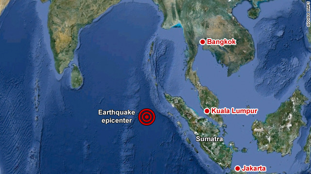
Tetemeko kubwa limepiga leo katika
pwani ya kisiwa cha Sumatra, Indonesia na
kusababisha uwezekano wa kutokea
Tsunami katika Bahari ya Hindi.Tetemeko
hilo limetwanga umbali wa kilomita 430
kutoka Banda Aceh mji mkuu wa jimbo la Aceh nchini Indonesia na lina ukubwa wa
8.7 kwa mujibu wa kituo kinachofuatilia
mienendo ya miamba cha Marekani (U.S
Geological Survey) na limepiga katika kina
cha km 33 chini ya bahari
Kwa mujibu wa kituo cha television cha CNN asubuhi hii kituo cha tahadhari ya
Tsunami cha ukanda wa Pacific kimetoa
tahadhari kwa nchi zote zilizo kando ya
Bahari ya Hindi kujiweka tayari kwa
uwezekano wa Tsunami muda wowote
kuanzia sasa na mamlaka ya Indonesia inayosimamia hali ya hewa,maumbile na
tabia nchi imesema imeshatahadhalisha
wananchi wa nchi hiyo
Umeme umekatika mjini Banda Aceh na
watu wamekuwa wakikimbilia maeneo
yaliyoinuka.Bado haijajulikana hasara iliyopatikana kutokana na mtikisiko huo Nchi zilizotakiwa kujiweka tayari ni
Indonesia, India, Sri Lanka, Australia,
Myanmar, Thailand, Maldives, British Indean
Ocean territories, Malaysia, Mauritius,
Reunion, Seychelles, Pakistan, Somalia,
Oman, Madagascar, Iran, Uae, Yemen, Comores, Bangladesh, TANZANIA,
Mozambique, Kenya, Crozet Islands,
Kerguelen Islands, South Africa,
Singapo

dah mkuu unatuwekea na tanzania kwa herufi kubwa,hapo full kunitetemesha,kifo mchezo...
 
Tanzania Tupo safe.
hizo nchi tajwa zipo ktk 'pasific ring of fire' ambayo ni belt yenye active volcanic eruptions na earthquakes.
kwa magnitude ya 8.7 sio mchezo. hiyo inaweza coz huge waves za tsunami ktk bahar especially Indian ocean coasts.
ikitokea Tanzania ikafika, kitakua kiji tsunami cha kishkaji tu. kama tides hivi!
 
Back
Top Bottom